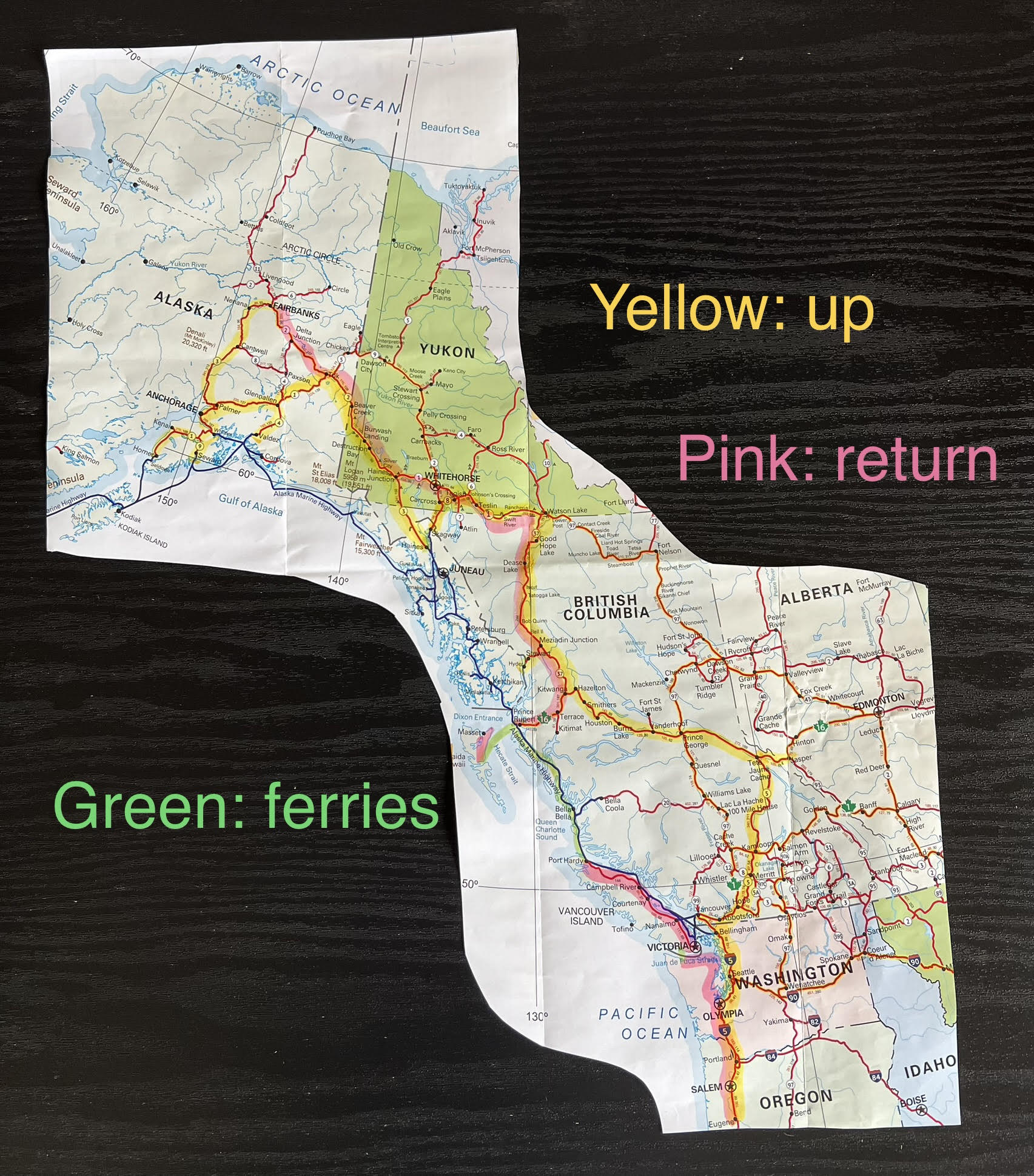
NORTHBOUND ONE: THE RIBBON ROAD

Plans, expectation,
the road climbs
Running quickly up to the Canadian border from our hub in southern
Oregon, we dashed through Portland, and spent the night at a forested rest
stop. We bypassed Seattle – the largest city on our route (700,000 population).
After visiting friends in Bellingham, we crossed into BC.
BRITISH COLUMBIA (BC)
Cultus Lake was a busy campground for locals. A lovely drive to it, except for the billboards that were such a throwback for us. The campground was great, forest and lake, spacious sites.


We re-visited Wells Gray Provisional Park for a quick peak at the outrageous Spahats Falls. Visible here, a section 60m tall (200').


After visiting friends in Clearwater, we were
jazzed to return to the magnificent Mt. Robson Provincial Park! The top is
rarely visible, with a nickname of Cloud-Top Mountain; lucky us.


Berg Lake Trail closed indefinitely after 2021 flooding. Luckily, the lower portion to Kinney Lake had just reopened, A great 14km hike toward the mighty mountain. We loved the trail markers.


Kinney Lake

Jasper, AB
Jasper remains one of my favorite locations so we slipped across the border into Alberta for a few days. Struggling with the pine beetle kill, Wabasso Campground still has a few trees while the other parks had to clear cut. We were surprised they did not have a fire ban, especially since Mt. Robson did, only an hour away!

Athabasca Valley from the top of the tram. Jasper town is the triangular piece surrounded by slopes and peaks and lakes with the river running North to the Arctic sea.

We re-visited favorite spots like Edith Cavell Mountain (see Ch 5) and Athabasca Falls below with thick mist from the raging water.

We were also able to visit some of the valley we hadn't gotten to.
Pyramid Lake is a family friendly multi-activity location with kayaking,
stand-ups, etc. We especially enjoyed Five Lakes Hike. When we started we
didn't really expect to see all five lakes but it was so accessible, it was a
really pleasant day.
Fourth Lake

Note red Adirondack chair on map between Third and Fourth Lake. An
Alberta thing: they are always located in scenic spots.

Amazingly, there was cell service there, so we got all kinds of messages, even making dental appointments for October at home.

We had done the hike in reverse order so these are Second and First Lakes, just stunning.


Yellowhead Hwy
Back into BC, we headed across Yellowhead Highway 16 toward the Hazeltons. We hopscotched through the fires. We had booked a couple days in Prince George but had to wear N95 masks and keep our air purifier going night and day.
Prince George air quality map. We were definitely in the hazardous zone.

Mama Yeh Campground (see X on map) at 5:30pm.

We got to a couple galleries but stayed inside as much as possible: Two Rivers Gallery.

Leaving Prince George, 9am.

We jammed on past any possible stops trying to get beyond the Bulckley-Natchez fires all around the corridor.
I had really wanted to stay at ‘Ksan campground but could never reach them when planning the trip. En route, they answered the phone and said the air was clear there.
True! so beautiful as we crossed the Bulkley just before it joins the Skeena River. We could remove our masks and breathe.


'Ksan Campground under the influence of Stekyoden Mountain; locals call it The Mountain.

It was an easy walk into the very small town along a stream, after passing through a field of raspberries. They were so good every day!

Cassiar Hwy
The Cassiar Hwy (37) would eventually take us to the Yukon (and back) but we deviated to take 37A to Stewart, BC first. So glad we did.

Rainey Creek, good name for the campground.

Hyder, Alaska is about two miles from Stewart and is in the lowest portion of Tongass National Forest. (This is the entire town, btw)

Our purpose in visiting Hyder was the Fish Creek Overlook, built to safely observe bears eating salmon. The salmon were late: no fish, no bears, no refund. The boardwalk was lovely and we did a nearby hike.

We drove out 20 miles on the gravel forest service road, back into Canada, to see Salmon Glacier (see Ch 5).

The drive was phenomenal. It must be said, the skies we saw were as dynamic as any other scenery.

Back on Hwy 37, the two-lane road, nearly 500 miles long, was built on the Cassiar plateau. We took it North and back again on our return.
We found a site for one night at Lake Kinaskan (kin-ASK-in), a remote provincial park campground. What a pleasant stop.


Hwy 37 seems eerily uninhabited, not even Bluetooth worked along here. Iskut area.

Dease Lake (and Hwy 37 still goes on)

Jade City (more of a store than a city). We had watched “Jade Fever,” a TV series about this operation, jade mining in the Cassiar mountains, the family, the buyers, etc.

Fun to watch the water-saw slicing big chunks.

YUKON (YT)

We finally reached the Yukon Territory. Just past the border we drove into Watson Lake and our devices started beeping again. The campground was not attractive but we liked the town. I judge a lot by the local grocery store and it was very good for its size; we restocked.
Watson Lake is most famous for its Signpost Forest!

It would have taken hours more than we spent looking at all the contributions. Unfortunately, we forgot to bring something fun to hang up from Kauai.
We enjoyed the Watson Lake planetarium. The only Northern lights we saw
this trip were in the gorgeous show there! The visitor center was outstanding
(as they all were in YT).
We had a nice hike all the way around Wye Lake, right in town. Quite a lot of bird activity on this lake. Just a little buggy, I got a few nasty black-fly bites.

Teslin Lake was our next hopeful campground – no worries, we got one of three sites right above the water.

The lake is over 90 miles long and, as we'll soon learn, ice fishing is very popular all winter.

Moose tracks (and size 13s)

We checked out the near-by George Johnston Museum featuring a well-presented large artifact collection, fun local history, and excellent taxidermy.
George Johnston is a well known Inland Tlingit man that embraced early modern technology including photography (1920-45), and buying a 1928
Chevy. He painted the car white in order to hunt by car on the frozen Lake Teslin in
the winter!
Restored here to its original dark green color.

After a detour to Skagway and Haines (see in Alaska section below), we travelled up to Haines Junction in the YT once again. The junction turned out to be more than a connection to the Alaska Hwy. It is First Nations land. We would interact with the Champagne/Aishihik people here later in the trip (see Ch 10).
The very impressive Kluane mountains.

ALASKA
Skagway
Mid-Yukon, we had detoured south to visit Skagway. The Klondike Hwy was
reportedly stunning. However, our drive down the mountains was entirely fogged
in, a white out, a little creepy on the steep grade (11%) towing a trailer. We
decided to revisit that drive a couple days later. It really was stunning!
Summit Lake


Skagway lies in the valley of the Taiya River, between steep mountains.

Yellow highlighting indicates places we visited in the area, some more than once. Note upper-left is the Chilkoot Trailhead.
The Chilkoot and other trails had been created and used for eons by clans
for trade conducted between the coast and the interior. Oil rendered from small
fish was an important trade item transported inland; the difficult paths were
dubbed the "grease trails."
Dyea was overrun by thousands clamoring for the Chilkoot Trail during the
Klondike Gold Rush. The original community no longer exists.
Skagway, however, is still cashing in on the Gold Rush as a tourist destination. The municipal focus is about one thing: the cruise ship passengers that pour in. Four cruise-ships per day with an average of 3,000 passengers each!

Typically, municipal campgrounds are cheek by jowl sites. At least we were at one end so only had close neighbors on one side.

Walking around the downtown madhouse one morning was enough. We found hikes and nature trails to explore for the rest of our time.

Taiya River bridge, the Chilkoot Trail started here, up and over the snowcaps.

Dyea Road (dy-ee) This area had been base camp for the Klondike Gold Rush and we visited it more than once. If we hadn’t needed shore-power, we could have camped off-grid near the rich estuary. (see CH 7:Birds)

East of town we hiked about six miles RT to Lower Dewey Lake. The first and last mile were steep switchbacks. Beautiful day.

The day we left Skagway, we parked at the ferry terminal early and hiked out to Yakutania Point west of town. Really lovely spot, easy to imagine what the natural harbor had once been.

Haines
On to Haines, a beautiful 45-minute ferry ride. Mountains and water, our
favorite combo, and we got to visit a friend. We checked out the Eagle preserve, and explored the area before heading North
to Haines Junction, Yukon.
Driving from the ferry terminal to the town of Haines.

Haines Museum with harbor behind. In stark contrast to Skagway, this was a real town with regular folks.

Hammer Museum (well, sort of regular folks). This was a very cool find. We also went to the SE Alaska State Fair for an afternoon (see Ch 4)

I had tried to book the campground at Lutak, a considerable way out of town, but never made contact. So glad, however beautiful to visit, it was nice to be around the sweet little town.
Lutak Inlet

Out the Chilkat River, we hoped for eagle sightings. They come in droves
in October/November, but not one in July! 
Apparently some full-time eagle residents nest in the woods across the river.

We stopped for a serene picnic lunch further up the Chilkat River.


US Customs
Welcome to Alaska
(Not so much)
NOTE: Border Crossings
We have crossed LOTS of international borders but nothing like entering Alaska above Skagway. We were totally unprepared for the two jerks on duty. Long story short, they took much of our fresh food including all the produce, eggs, and even frozen chicken. It went into a spotless white bucket, bragging that they had taken so much more from other people! Nothing we could do.
Crossing back into the Yukon, there were no restrictions at the border. The Canadian customs official told us the avian flu warnings had been lifted weeks earlier (the excuse for taking eggs and poultry). He only wanted to know if we had guns.
Reentering Alaska from the Yukon on the Alcan Highway, was again no
drama, no food restriction. If we were not moving wood, live plants, or drugs,
they were okay letting us in.
Our next coastal destination would be Valdez on Prince William Sound. Four hundred miles as the raven flies. However, by road it was 700 miles (up to Tok then south to the coast).
Leaving the Kluane mountains we were on the one-and-only Destruction Bay
Road that led us back into Alaska, where we would be for the next month. The
road is considered the roughest of the entire trip (unless you attempt the
Dempster which we were not foolish enough to do).
Teeth rattling tight washboard, you cannot go slow enough. We were lucky to have such a well-built trailer with our things tightly secured. Even so, one cupboard opened, dropped cups, and slammed shut again! It could have been so much worse.

PERMAFROST

Discontinuous permafrost (the mauve area on the map) is a real issue for Alaska. When roads are built on top, it tends to melt and refreeze causing serious potholes and heaves. Road crews try to keep up with the damage.
There are two seasons in Alaska: Winter and Construction. We were not alone.

Heaves

Repaired heaves

Stopped for construction repeatedly, we liked this homemade camper at one stop. Unfortunately, one of the road crew here was hit by a large motor home that failed to stop. It was a very long wait (and made us so thankful for a smooth trip).

Hard to get a clear picture from the truck vibrating over the washboard road.

Tok – The Hub of Alaska
Tok (rhymes with smoke), is a crossroads calling itself the Hub of
Alaska. It is not incorporated, not a city or town or village. We needn’t have
spent two nights there or at the next stop, Glenallen. Nice enough countryside,
they were both simply crossroads. Who knew? All we needed was gas and a few
groceries. We did some laundry at the campground.
Highway between the two non-towns

Glenallen was the winner of the trip for mosquitos. We had face nets from the previous trip and this year we brought net overshirts as well. This was the only place Gil needed his shirt just to unhitch/hitch the trailer.
Unusual rains a couple weeks earlier created flooding but the campground is on permafrost and the water just pooled, ie, mosquitos! Locals said it was the worst in decades. For good reason, this picture was from inside looking out.


We used the wi-fi at the library, the clever password was Orwell1984. They were very kind and cleared a desk so I could catch up with our banking.

On to Valdez
We took the Richardson Hwy south, heading to Valdez. Spectacular terrain.


Some construction stops you don’t really mind, glaciers abound.

This perpetual waterfall would be visible from Valdez town, and was actually used as a landmark for directions: “right before the waterfall,” or “about a mile past the waterfall.”


The campground was behind the estuary but another row of campers blocked our direct view. Very nice hosts, they even provided coffee in the morning and had some of the cleanest restroom/showers of the trip.
The estuary at Valdez. We expected more birds than we saw. We planned a hike out to the point at right but were told not to go without bear-spray. Unsure if they were being overly cautious, we skipped the hike. We opted for a boat instead.

11pm at the campground

We basically walked across the street to the harbor. We compared the different tour boats and chose Stan Stephens.
The boat tour into Prince William Sound was the highlight of the time spent here. (See CH 6 for the marine animals, and see Ch 5 for the glaciers.)

Leaving Valdez, richly rewarded!

Mt. Blackburn stood out across Willow Lake toward the east side of Wrangell-St. Elias Park. It hadn't been visible when we drove down.

We drove on to Glacier View to spend our 40th wedding anniversary. (The whole trip was a celebration.)
Lion's Head

We could see the Lion from our dining table, and from a lovely trail below our campsite to the valley.


We explored the area for a couple days, with great weather.


We followed the glacier fed Matanuska River all the way to Palmer. The Glenn Hwy is very scenic between the Talkeetna mountains on the north and the Chugach to the south. On to Big Lake, North of Anchorage. (See Ch 4)
Chickaloon Mountain

Kenai Peninsula, AK
The Kenai is very special. We went to Portage Valley, Homer, Soldotna,
and Seward before heading into Alaska’s interior. We followed Turnagain Arm
across the top of the peninsula.
I had seen a Beluga whale here four years ago but no luck this year. The
craziest bore tides occur here – careless people that walk out onto the sand
don’t have time to get back in when it rises; they simply drown!
Beluga Point on Turnagain Arm

Entering Portage Valley

Williwaw Campground, the wettest experience of the trip. Hard to keep the window clear in the truck.

We were pleased the site itself was a rough asphalt, thick with pine needles, not mud. Yay!

We love Portage and hiked in the rain, watched the salmon spawning and got lost on some of the trails as we tried to figure out which glacier was which above us. Luckily, we had rain gear. I did forget to put my rain pants back on for one hike and had to wring my jeans out!

Salmon spawning

Continuing on, we drove back west on the Sterling Hwy through Cooper Landing. In 2019, we had to follow a pilot car through here during the massive fires. It was emotional to see the damage left (170,000 acres had burned).

Homer
Ocean Shores at Homer was the most scenic campsite of the trip, on a cliff looking over Kachemak Bay. I have to say the wind kept me awake one night. It was so strong I imagined the trailer rolling down the cliff. It was ridiculous of course, beautiful morning. (See map of Homer in Ch 5)

We had this view from our bed.

Over the next few days, we walked down the path to the beach directly below us several times, drove out to the spit, and all along Homer's East End Road, past the town. Really nice mixture of normal life, fishing industry, and tourism. Gorgeous place.

Homer Spit is a charming, finger of land extending from town into Kachemak Bay. The spit of 4.5 miles long features the harbor. Boat tours offer fishing and rides cross the bay.

The iconic Seafarer's Memorial, clearly a serious fishing village.

Lands End is the tip of the spit.

From Homer's East End Rd across the bay to glacial mountains.

Seward
On our way to Seward we visited friends in Soldotna (see Ch 4).
Seward is located on a cove leading to Resurrection Bay and the Gulf of Alaska,
North Pacific.
Seward Highway

I had fallen in love with Seward on our previous trip and was excited to visit the area again. All the city campgrounds were at the waterfront. We did expect the typical arrangement of sites packed like sardines and booked one near the shower house for convenience.
Seward Municipal Campgrounds

However, the poor maintenance was inexcusable – the shower house was padlocked shut and the porta-potties did not even have hand sanitizer! Derelict, graffitied trash-bins out our window looked like inner-city imports.
We did what we do, made the best of it. We found a gym down-town for
showers and a lovely library with Wi-Fi to hang out during one very rainy day.
The waterfront itself was great.

10pm sunset

The harbor was a little nuts with a fishing derby going on. We had toured the awesome Kenai Fjords before, by boat, and did not repeat here as we had just been out at Valdez.

The nature aspect is fabulous due to the location. Besides walking the waterfront, we drove out to Lowell Point where we had not ventured before.
Lowell Point Road

Much calmer at this distant campground. Glad we got to explore the Point even if it was too rainy to hike in the incredible rainforest.

I found the dream home for my sister-in-law!

The clear weather arrived too late, we missed the opportunity for flightseeing over the mountains. We departed Kenai on a most spectacular day.

THE ALASKA INTERIOR
Anchorage had been flooding so we just passed through and stayed one relaxing night in a woodsy park at Lake Lucille before going on to Denali.


Foraging rose hips for tea

Denali
We had been to Denali and Fairbanks by train but this time we were driving. The Park campsites at Riley Creek were much better than expected – forested, spacious, with clean, working shower houses. The park is well organized with shuttles and busses.

When the park was first set aside there was discussion that having no road access would actually preserve the wilderness; only hiking and sled-dogs (the transportation of choice in winter).
However, one 92-mile gravel road was built into the 6-million-acre park, and the park service has run various busses for visitors to observe the scenery and wildlife. Private cars can only go to Savage River, fifteen miles in.
We did drive out to Savage Run a couple times, hoping to see wildlife but
very soggy conditions made visibility short. Luckily, we had been in better
weather before and even saw the great mountain, Denali, formerly Mt. McKinley.
This trip, we were very pleased to visit friends who live in nearby Cantwell in the summer (see Ch 4). Regardless the weather, the landscape in the cradle of the Alaska Mountain Range is jaw-dropping.

One of the railroad bridges over the Nenana River. Gil was a little nervous as I walked to the edge of a cliff to get the shot.

Six million acres


Fairbanks, AK
A couple weeks earlier, there were heavy fires reported near Fairbanks and we looked for an alternate route back down to the lower 48 (as Alaskans call it). But the rains came (yes they did) and the fires were no longer an issue.
Fairbanks was our Northernmost destination and the turning point. We
were happy to stick to the itinerary: two months up and one month back down.
Rainy mist, not smoke, thankfully

We had three items on our Fairbanks agenda: birds, Northern lights, and the museum at the university. In 2019, we had seen the lights and some of the museum, but the nesting birds had migrated before we got there – nary a one!
With rainy clouds there would be no Northern lights this time but the museum was great; we visited twice. The birds had not yet left and we spent hours with them at the various grounds.
Creamer’s Field had been a dairy but was now dedicated to the nesting Sandhill Cranes and was on the migration path of non-nesting birds (see Ch 7 for more feathered details).

We also enjoyed the Wedgewood Wildlife trails, one around the lake and others through the boreal forest.
Wander Lake

Taiga Trail, Gil among the Paper Birch trees

Museum of the North on the University Campus

These flowers may have been spent already at lower latitudes but were prime here outside the building.

Fairbanks was our turning point, and we were so happy we actually got to visit this time. We would now head down, passing through Tok, the Hub, again and begin our return journey toward the Lower 48.


Comments
Post a Comment